The William and Susan Higgins Cooper Family
1848
William B. Cooper and Susan Higgins were the parents of Nancy Cooper
who married Benjamin Simpson; the brother of my great great great grandfather
William Simpson. I don’t know when they departed Missouri to cross the Oregon Trail
or if I have all of the Cooper children listed (there are more but I can’t put them on the Oregon Trail), but William didn’t make it. He is buried somewhere on the plains on the trail.
Barbara, William R., Philomen and Jaly married in Oregon 1850-1860, and I don’t know how or when the spouses arrived in Oregon. It is unknown if Susan remarried. Click on William’s name below to go to his entry in my GEDCOM on WorldConnect Project.
1848 1 William B. Cooper b: ABT. 1788 d: 1848
1848 + Susan Higgins
ID: I02647 | |
Name: William B. Cooper | |
Sex: M | |
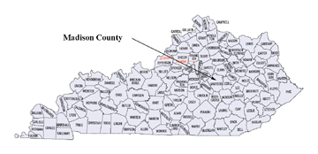
Birth: ABT. 1788 in Madison Co., KY |
| |||
Note:
|
Children
_______________________________________________________________
|
Copied from pages 14 and 15 of “THE PLATTE PURCHASE, The Simpson and Cooper
Families, 1836 – 1846″, by Kirke Wilson, San Francisco, August, 1999.
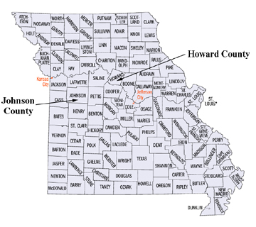
Born in Madison County, Kentucky, William Benjamin Cooper (1797/8- 1848) was the sixth of ten children of Benjamin and Anna Fullerton Cooper and cousin of the Browns.54 As a young man, William Cooper had been active with his brothers and cousins in the defense of the Boonslick forts during the War of 1812. He also participated briefly in the fur trade when he and his cousin Joseph Cooper assisted mountain man Ezekiel Williams to recover furs hidden on the Arkansas River during the winter of 1814-1815.55 In 1818, William B. Cooper married Susan Higgins at Cooper’s Fort in Howard County, Missouri. Susan Higgins Cooper (1801-1877) was the daughter ofJosiah Higgins (1782-1841) of Tennessee and Barbara Smelser Higgins (1779-1840). The Higgins family had lived at Coopers Fort at the end of the War of 1812.56 After his marriage, William Cooper is likely to have accompanied his father and cousins on the second successful trading expedition on the Santa Fe Trail in 1822.57 He later served with the Illinois Mounted Volunteers in the Black Hawk War of 1832.
William and Susan Higgins Cooper owned land in Howard County near the William Simpson family and lived for several years in Saline County, Missouri. When they moved to the Little Platte, they claimed the southwest quarter of Section 7, Township 51 North, Range 34 West four miles north of the Platte River in Pettis Township. The Cooper land is on the west side of road N eight miles due south of Platte City on both sides of a tributary of Brush Creek. The land is near the present day intersection of 1-435 and SR 152 approximately three miles southwest of Kansas City International Airport.58 The Cooper land was adjacent to a parcel owned by Alvis Kimsey and a mile south of the Platte County property owned by William Simpson. William and Susan Higgins Cooper lived three miles west of 320 acres owned by her brother Jacob Higgins and 160 acres owned by her brother Philemon Higgins.59 The land was also about four miles northwest of 240 acres in Pettis Township owned by Susan Cooper’s cousin Jacob Smelser (1805-1888), a Platte County Justice of the Peace.60 Her father, Josiah Higgins was a prominent Plate County pioneer. Josiah Higgins was elected a Justice of the Peace for Pettis Township in the fast Platte County election in 1839. At the time of the 1840 census, he owned four slaves including an adult woman and three children.61 Josiah Higgins died in Platte County in 1841. William Cooper served as Secretary in the probate of the 1841 eastate of his father-in-law Josiah Higgins.62
On June 8,1843, the paths of the Cooper and Simpson families converged when Nancy Cooper (1820-1883), the daughter of William and Susan Higgins Cooper married Benjamin Simpson the son of William and Mary Kimsey Simpson. Over three generations the Coopers had moved from Virginia to frontier Kentucky and Missouri. The Simpsons began their journey from Maryland a generation before the Coopers left Virginia but avoided the frontiers and moved more frequently. They settled at two locations in North Carolina, one in Tennessee and two in Missouri before moving to the Little Platte. The William Cooper and William Simpson families had been neighbors in the 1820s in Howard County and were neighbors twenty years later in Platte County when Nancy Cooper married the young widower Benjamin Simpson.63
The following is from a letter from Kirke Wilson to Lynn Beedle:
 KIRKE WILSON.. 172 HANCOCK STREET..SAN FRANCISCO 94114
 28 November 1997

 Dear Lynn:
 My wife Anne and I recently returned from a mid-western trip. I had meetings in
 Dayton and Kansas City and combined business with several days in Missouri
 including the Boonslick area in the central part of the state and the Platte area of
 Western Missouri. In the Boonslick area, we stayed at a bed and breakfast in
 Arrow Rock (an historic town where the Santa Fe Trail crossed to the South side
 of the Missouri River, also the home of Dr. John Sappington and George Caleb
 Bingham) and spent time with local historians.  Anne and I were successful in
 resolving several questions and locating several sites which had previously
 eluded me:

 1. The location of Sarshel Cooper's bloody shirt:
 I had heard the story that the shirt that Sarshel Cooper was wearing when he was
 killed by Indians in 1815 at Cooper's Fort was displayed at the old Arrow Rock
 Tavern. In previous visits, the tavern was always closed and I was unable to verify
 the story. While the Tavern was again closed (for a funeral), I was able to locate
 the shirt in the State Visitors Center (a museum) at Arrow Rock. The "shirt" is a
 stained piece of plaid fabric approximately four inches by five inches mounted on a
 hand-written card claiming that the cloth was from Sarshel's vest and had been
 preserved by Sarshel's grandson Nestor Boone Cooper. Whether or not this is
 actually the shirt, it is part of a well-organized local history exhibit which
 includes a few artifacts and many visual representations of the early period including the salt
 manufacturing at Boone's lick, the Cooper settlement and Indian wars and the
 establishment of the Santa Fe Trail.

 2. The location of the Benjamin Cooper property in Howard County:
 In previous visits, I had located and visited the site of Coopers Fort but had never
 located the property Benjamin Cooper had claimed after the War of 1812. The
 site of the fort is marked and is 9/lO of a mile west of Petersburg on Road 330
 (a gravel road through farm lands on the Missouri River Bottoms). Petersburg is
 an uninhabited village 9.7 miles west of the US 40/SR 87 junction on Road Z (the
 north end of the bridge across the Missouri River from Boonville). The 40/87
 junction is approximately the location of Old Franklin (the beginning point of the
 Santa Fe Trail) which was wiped out by floods in 1828 and relocated to higher
 ground. The route from the junction to Coopers Fort is along the edge of wooded
 hills and follows the route of the Santa Fe Trail.  The Benjamin Cooper property
 is on the north side of Road 330 and west of Road 337. The Santa Fe Trail (unmarked)
 was the southern boundary of the Cooper land (the gravel road ends after 1/2 mile
and the Missouri River has moved away  from Arrow Rock and closer to the Cooper
property). It appears that the fort was located on a slight rise in an otherwise
treeless bottom land where soil was rich and sneak attacks would be difficult.

 3. The Benjamin Cooper Cemetery:
 Since my last visit, the South Howard County Historical Society has marked and
 fenced the cemetery in which Benjamin Cooper (our great-great-great-great
 grandfather) and his wife Anna (according to other sources she was Anne
 Fullerton Cooper-our 4 great grandmother) are buried. The little cemetery is in a
 pasture surrounded by woods 9.4 miles from the 40/87 junction on Road Z. The
 cemetery appears to have 38 marked graves (it is unclear who) but only six with
 headstones. Benjamin and Anna have proper headstones (in reasonably good
 condition) and foot stones as well His grave is also marked by the DAR for
 Revolutionary War service.

 4. The Sarshel Cooper Tombstone:
 Many years after his death in 1815, the descendants of Sarshel Cooper had a fine
tombstone cut but the tombstone ended up in a museum at Central Methodist College
in Fayette (where the tombstones of Daniel Boone and his wife remain to this day).
Someone in the 1990s, at least 175 years after his death, the tombstone caught up
with his remains (which had been unearthed in one of the many Missouri River
floods). He is buried in the Joseph Cooper (his son) cemetery 8 miles from the 40/87
junction on Road Z. This cemetery is smaller than the Benjamin Cooper cemetery but
has an iron fence and is locked. This cemetery is also on a wooded hillside and is
maintained by the South Howard County Historical Society.

5.  The other War of 1812 forts:
Coopers Fort was the largest and strongest of the Missouri forts built at the time of
the War of 1812. Several other forts were built and used during the same period in
the Boonslick Region. With help from a local historian, I was able to locate the
(unmarked) site of Fort Hempstead and to obtain directions to the other forts.

6.  The Thomas Simpson grave and William Simpson land in Johnson County:
I know the general location of the land and where the tombstone was many years ago
but was not able to stop in Johnson County this trip.

7.  Simpson and Cooper Property in Platte County:
Using a variety of old and current maps, I was able to locate the land that William
Simpson, William Cooper and others claimed in Platte County in the 1840s. The
lands were a mile apart (perhaps contributing to the marriage of Nancy Cooper to
Benjamin Simpson after his first wife died in childbirth) and a few miles
southwest of what is now Kansas City International airport. The lands, along with
quarter sections claimed by James Simpson and various Kimsey relatives, are
seven miles due south of Platte City on Road N (4th Street in Platte City).
Road N is along the west side of the William Simpson property and into the
William Cooper property. The land is well-watered, rolling hills and several
miles away from the Platte River and the Missouri. The land is being farmed
but includes some recently-built suburban houses on large lots. The Cooper
property is near the intersection of 1-435 and SR 152.

8.  The death of William Cooper:
For all the Platte County documentation of land ownership and marriages, there has
always been some element of mystery about William Cooper. We have evidence of
his participation in the War of 1812 and the Black Hawk War. From others, we know
of his involvement in the fur trade and his travels on the Santa Fe Trail We know he
had ten children (including several who went to Oregon) but I have found no
documentation of the story that he died crossing the plains sometime between 1848
and 1851 and that his widow Susan Higgins Cooper (our 3 great grandmother)
married for a second time in Oregon in 1856 (I suspect that this will be easy to
confirm—I simply have not researched Oregon marriage records yet).
When Anne and I were at the National Frontier Trails Center in Independence,
Missouri, I found evidence that five persons named William Cooper had been on the
trail between 1849 and 1852. Four of the five seem unlikely to have been our William
(Pittsburgh Company of 1849; St. Louis Company, no year; Iowa Company, no year;
from Rome, Ohio in 1852). The best candidate (who may be the same person as the
Rome, Ohio William Cooper) is someone who died 4 June 1852 on the trail to
California.   The California destination is unlikely.  Our William had his oldest
daughter in Oregon (our two-great grandmother Nancy Cooper Simpson) as well as
other children and we have reason to believe that his wife went to Oregon. The June
4 date is early enough (using 1846, they would have been somewhere near Fort
Laramie and far before the trail split) that companies may not have decided on their
destination. According to the best estimates, 50,000 of the 60,000 on the trails in
1852 went to California. As a consequence, it is possible that this William was part
of a large party, most of which went to California but some of which, including his
widow, went to Oregon.
I took photographs of some of these sites. Unfortunately, in my rush to catch the
plane, I left the camera in the rental car and lost both the camera and the roll of film
with the Sarshel graveyard and the Platte County properties of William Simpson, the
Kimsey's and William Cooper. As soon as I get duplicates, I will send some photos
of the Boonslick.
I have very much enjoyed Helen's recording of 19th century music and Jonathan's
vocals. Perhaps it is the power of Ken Bums, but I am very fond of "Believe me if
afl those endearing young charms" and "Lorena".  My guide in Boonslick, Bob Dyer,
in addition to editing the Boone's Lick Heritage is also a poet and folksinger. Anne
and I bought "Rebel in the Woods: Civil War Songs from the Western Border" which
Bob recorded with Cathy Barton and Dave Para of Boonslick. My fantasy would be
a joint concert bringing together these disparate views of the same period.
I will keep you informed of my progress.